Cartographic irritations
/Yesterday I ran across this Big Think “Literary Map of America.” As always with such things, it was so detailed and so nicely designed that I got excited about it. As always with such things, when I zoomed in on the places I care most about, I was disappointed.
I am pleased to see Tim Powers’s Last Call on the map for Las Vegas, Elmore Leonard’s Get Shorty for LA and Rum Punch for Miami, Travis McGee in Fort Lauderdale, The Killer Angels in Pennsylvania, Walt Longmire’s Absaroka County in Wyoming, and Faulkner’s Yoknapatawpha County in Mississippi, but when I looked at Georgia and Upstate South Carolina—the two places I’ve lived my entire life—I was disappointed and finally just annoyed.
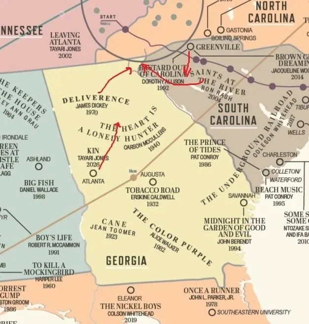
First, with regard to my homestate: The map labels Atlanta in entirely the wrong place, somewhere south of Newnan. Augusta is, absurdly, labeled just east of Macon when Augusta sits on the South Carolina line (and, indeed, I sometimes get students from Augusta). Deliverance takes place mostly along a fictional river in northeast Georgia (the novel explicitly says “the northeast part of the state,” a detail I’ve grumbled about here before; the boys’ drive up from Atlanta closely matches the drive toward Gainesville; and, though there’s not necessarily textual justification for this, I’ve always taken Aintry to be a fictional stand-in for Toccoa).
But what I noticed first, given the clutter in other areas, was how much blank space is left over in Georgia. No Gone With the Wind? No Ferrol Sams? No Flannery O’Connor? “A Good Man is Hard to Find” by itself is an authoritative slice of the middle part of the state. Tom Wolfe’s Bonfire of the Vanities is labeled in New York, why not A Man in Full for Atlanta? You could throw in a couple of Eugenia Price novels like Lighthouse or The Beloved Invader for the coast. I’d even take Andersonville.
Second, and closely connected, South Carolina: The designer places Greenville too far to the northeast, closer to Gaffney than anything else. I was pleased that the map includes Ron Rash but Saints at the River, which is based on a real incident on the Chattooga River, takes place in a mixture of real and barely fictionalized locations on the Georgia-South Carolina line (the Long Creek area of Highway 76 is clearly recognizable) while the map puts the title in the Newberry area, far from the mountains. And if we’re including even one Ron Rash, why not One Foot in Eden, which is set in the Jocassee Valley before it was dammed and flooded?
The decisions get more baffling from there. Styron’s Confessions of Nat Turner appears beside the non-existent town of Southampton on the York River when the book (and real incidents Styron based it on) takes place in Southampton County, which is on the Virginia-North Carolina line. True Grit’s Mattie Ross is from Yell County but her story mostly takes place across the border in Indian Territory, aka Oklahoma. Blood Meridian, which begins in Tennessee before bringing the Kid to Nacogdoches, Texas and finally northern Mexico, where most of the famously violent incidents occur, should earn one of the long lines marking a journey but is squeezed into the lower Rio Grande Valley. No Country for Old Men doesn’t appear, though there’s plenty of space around El Paso. And as someone on Substack pointed out, New Mexico apparently matters so little that most of it is obscured by an inset map of West Virginia. A connection who has written fiction about southeastern Ohio felt a similar annoyance.
Whatever. I know a lot of this is down to space constraints and that you just can’t fit everything in or please everyone. But look at how densely packed a place like New York is (of course) and it’s easy to see the Frogpondians taking more care over themselves than anyone else. And that’s assuming AI played no role in this map’s creation.
Probably this map will be adequate for most people, and may even grace an English classroom wall somewhere, but some of the wooded, hilly parts of the country could stand better treatment.